This is one of the most beautiful marathon routes in New England. The course starts at the Potash Hill campus in Marlboro, in the Green Mountains of Vermont, follows the Green River as it flows down toward the Connecticut River, and ends at Greenfield Community College in Greenfield, Massachusetts. Along the way, racers will pass beneath beautiful forests, glide past historic farms, and run across an 1870’s covered bridge. Runners will catch amazing views of the river itself (which really is green in places), and breathe in the delightfully fresh air of the Green Mountains and the Berkshires.
This is a net downhill (-1,459 feet) marathon (26.2 miles), and as such is a good candidate for a marathon PR and a BQ. The course has 650 ft. (198.1 m) of uphill and 2109 ft. (642.8 m) of downhill, for the net 1459 ft. net downhill. Our course does not fall under the BAA’s downhill results indexing because its net downhill is less than 1500 feet. Keep in mind that this isn’t an easy course; no marathon is, and this one does have a few hills! But if you train right, it could be a fast one for you. The course is USATF-certified and is a qualifying race for Boston (Certification number MA18003JK). It was measured using a calibrated wheel device as per USATF regulations. The road surface is mostly packed dirt-and-gravel with a few sections of pavement until mile 21, and there are 5 miles of pavement at the end. Runners should train on dirt roads, rolling hills, and long downhills to prepare. Experienced marathoners complain about their quads after this race, so train for those downhills!
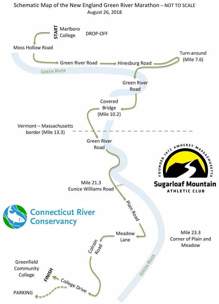
Detailed description:
The course starts at the campus of the Potash Hill campus in Marlboro, Vermont, and heads steeply down the packed dirt-and-gravel Moss Hollow Road for 2 miles (with one uphill). The course then turns left (mile 2) onto Green River Road. This mostly downhill section is paved for 3.9 miles, and then continues on packed dirt road. Green River Road takes on the name Hinesburg Road which runners will follow up a small hill to the turnaround spur (mile 7.6). After completing this spur, runners will turn left (south) onto the packed dirt-and-gravel Green River Road (mile 8.1). At mile 9.7 runners will climb slowly up the first significant hill of the course (which isn’t much, actually) and then downhill and across the beautiful Green River Covered Bridge in Guilford, built in the 1870’s (mile 10.1). To the right of the bridge is the Green River Crib Dam built of logs and stone in 1810. A beautiful 3.4 miles down dirt road from the covered bridge is the Vermont – Massachusetts state line, marked by a granite post up on the hill to the right (mile 13.3). This is obviously very near the halfway point of the race. 1.6 miles past the border, runners will come back onto the pavement for another 1.2 miles, after which they will stay left to remain on Green River Road (this is at the junction of West Leyden Road at mile 16.4). About 500 feet later, the pavement ends and runners are back on packed dirt-and-gravel for the next 5 miles. A half mile after regaining the dirt road, runners will bear right at a fork to remain on Green River Road. Starting at mile 17, for the next 0.4 miles, runners will climb what we call “Airstream Hill” for the vintage airstream trailers that used to be parked there; this hill rises 80 feet over that distance. From the top of the hill, at 111 Green River Road (marked on a prominent mailbox), runners have 3.1 miles of mostly downhill through one of the most beautiful parts of the course until reaching the most challenging hill on the route at about mile 20.8. This is our own “heartbreak hill”. CAUTION: Runners should be extremely careful on this big hill, as the curves are tight, sight-distance for traffic is limited, and there are dangerous drop-offs on the left side of the road. This hill rises 85 feet in a half mile. From the top of the hill, there’s another half mile of dirt road. Then from Eunice Williams Road, it’s about 5 miles of mostly downhill on paved rural and suburban roads through the Greenfield Meadows section of town. Runners bear left on Plain Road, and then the course turns right on Meadow Lane (slight uphill grade), then left on Colrain Road. Runners will stay to the right right on Colrain Road. At the GCC rotary, the course turns right and climbs slightly up the wide, paved College Drive to the finish (on the grass) at Greenfield Community College. Much of the last five miles of this course are on pavement and un-shaded, so be prepared for the heat!
Aid Stations
Amenities codes:
W=Water
T=Tailwind Endurance Fuel
U=Untapped Maple Athletic Fuel gels
P=Port-a-potty
M=Medical station
F=Food
B=Beer
| Mile | Distance to next | Station | Open | Close | Amenities |
| 3.3 | 2.8 | Apple | 7:16 AM | 7:49 AM | WT |
| 6.1 | 2.9 | Beaver | 7:30 AM | 8:31 AM | WTP |
| 9 | 3 | Crayfish | 7:45 AM | 9:15 AM | WTUP |
| 12 | 2.8 | Duck | 8:00 AM | 10:00 AM | WT |
| 14.8 | 1.6 | Eagle | 8:14 AM | 10:42 AM | WTU |
| 16.4 | 1.6 | Fern | 8:22 AM | 11:06 AM | WTP |
| 18 | 1.9 | Goldfinch | 8:30 AM | 11:30 AM | WTU |
| 19.9 | 1.5 | Hummingbird | 8:39 AM | 11:58 AM | WT |
| 21.4 | 1.9 | Iris | 8:47 AM | 12:21 PM | WTUP |
| 23.3 | 1.2 | Jewelweed | 8:56 AM | 12:49 PM | WT |
| 24.5 | 0.95 | Kestrel | 9:02 AM | 1:07 PM | WTU |
| 25.45 | 0.75 | Lark | 9:07 AM | 1:21 PM | WT |
| 26.2 | Finish | 9:11 AM | 1:33 PM | WTUPMFB |
Course Map
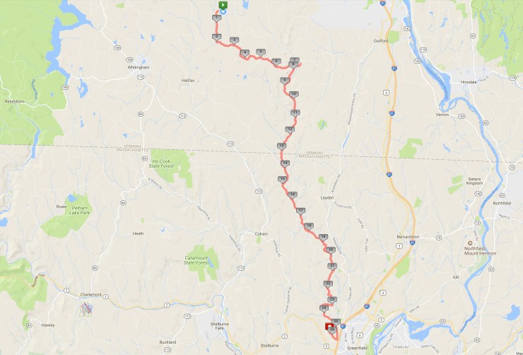
GPS information: This bike ride follows the marathon route. It is a little longer than the official measurement because it’s not on the tangents, plus some probable GPS error. Includes facility to download GPX, CSV, and KML files.
Elevation Profiles:
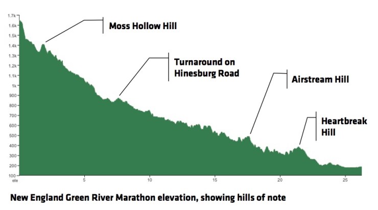
Profiles showing slope grades:


And a simplified overview: